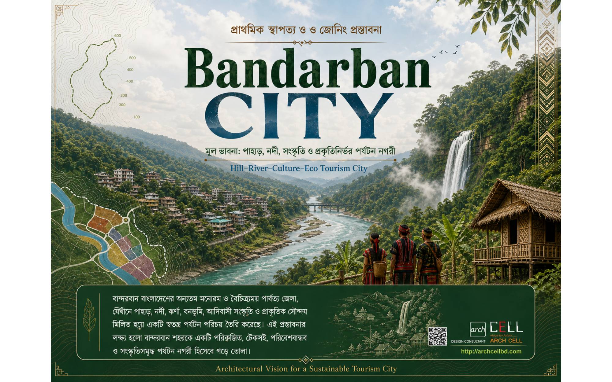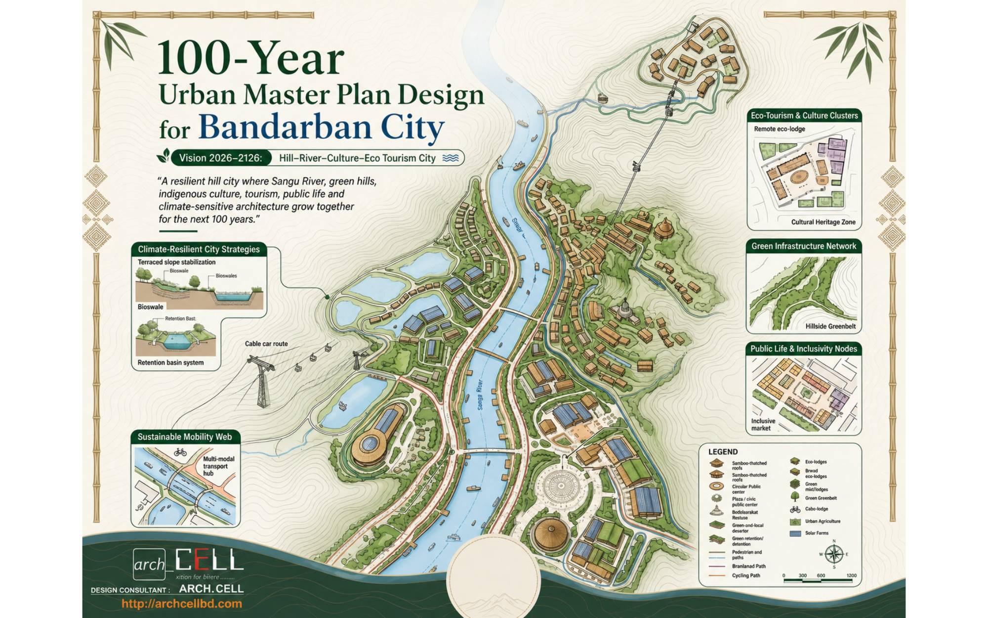
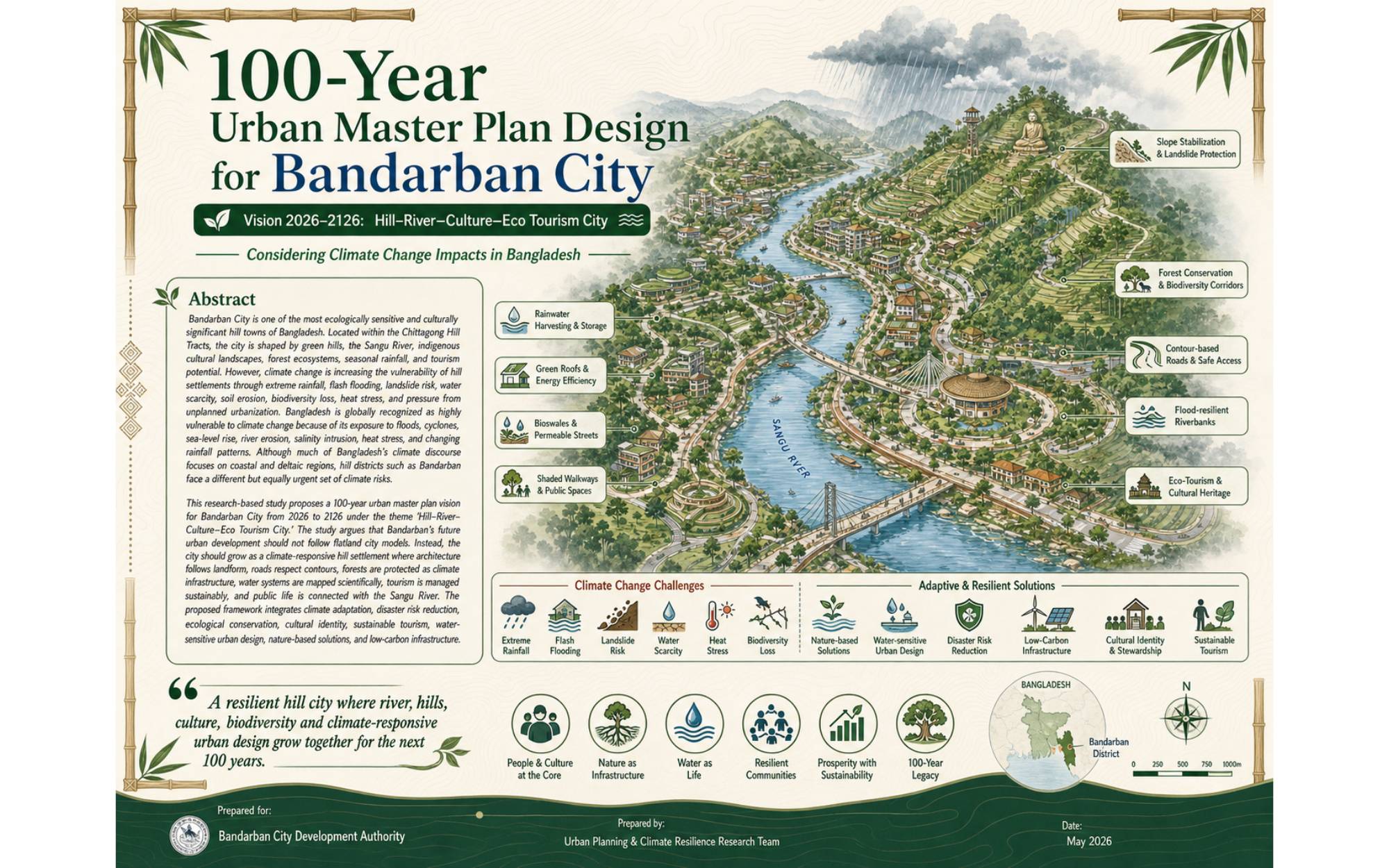
100-Year Urban Master Plan Design for Bandarban City
Vision 2026–2126: “Hill–River–Culture–Eco Tourism City”
Considering Climate Change Impacts in Bangladesh
Abstract
Bandarban City is one of the most ecologically sensitive and culturally significant hill towns of Bangladesh. Located within the Chittagong Hill Tracts, the city is shaped by green hills, the Sangu River, indigenous cultural landscapes, forest ecosystems, seasonal rainfall, and tourism potential. However, climate change is increasing the vulnerability of hill settlements through extreme rainfall, flash flooding, landslide risk, water scarcity, soil erosion, biodiversity loss, heat stress, and pressure from unplanned urbanization. Bangladesh is globally recognized as highly vulnerable to climate change because of its exposure to floods, cyclones, sea-level rise, river erosion, salinity intrusion, heat stress, and changing rainfall patterns. Although much of Bangladesh’s climate discourse focuses on coastal and deltaic regions, hill districts such as Bandarban face a different but equally urgent set of climate risks.
This research-based study proposes a 100-year urban master plan vision for Bandarban City from 2026 to 2126 under the theme “Hill–River–Culture–Eco Tourism City.” The study argues that Bandarban’s future urban development should not follow flatland city models. Instead, the city should grow as a climate-responsive hill settlement where architecture follows landform, roads respect contours, forests are protected as climate infrastructure, water systems are mapped scientifically, tourism is managed sustainably, and public life is connected with the Sangu River. The proposed framework integrates climate adaptation, disaster risk reduction, ecological conservation, cultural identity, sustainable tourism, water-sensitive urban design, nature-based solutions, and low-carbon infrastructure.
Keywords
Bandarban City, 100-Year Urban Master Plan, Climate Change, Hill City, Sangu River, Eco Tourism, Nature-Based Solutions, Landslide Risk, Water-Sensitive Urban Design, Bangladesh Urban Planning
1. Introduction
Bandarban is one of Bangladesh’s most distinctive hill districts, known for its mountains, valleys, river systems, waterfalls, forests, ethnic diversity, and tourism appeal. Unlike many lowland cities of Bangladesh, Bandarban’s urban form is directly influenced by slopes, drainage channels, forest edges, river corridors, and fragile hill ecosystems. These characteristics make the city environmentally valuable but also highly vulnerable to unplanned development.
A conventional urban expansion model based on road widening, hill cutting, uncontrolled construction, and excessive concrete would create severe ecological damage in Bandarban. Therefore, a 100-year urban master plan is required to guide the city toward a resilient, climate-responsive, culturally rooted, and tourism-oriented future.
The proposed vision for 2026–2126 is:
“A resilient hill city where the Sangu River, green hills, indigenous culture, tourism, public life, and climate-sensitive architecture grow together for the next 100 years.”
This vision reflects the need to treat Bandarban not only as a tourist destination but also as a living ecological city where local communities, natural systems, and cultural identity remain central to urban development.
2. Climate Change Context of Bangladesh
Bangladesh is highly exposed to climate change due to its geographic location, dense population, low-lying deltaic landscape, monsoon climate, and dependency on natural resources. Major climate-related risks include flooding, cyclones, river erosion, sea-level rise, salinity intrusion, heat waves, erratic rainfall, drought, and biodiversity degradation. The Intergovernmental Panel on Climate Change identifies South Asia as a region facing increasing risks from extreme heat, intense rainfall, flooding, and climate-related disasters under future warming scenarios (IPCC, 2021; IPCC, 2022).
Bangladesh has developed several national policy frameworks to address climate risks, including the Bangladesh Climate Change Strategy and Action Plan, Bangladesh Delta Plan 2100, Nationally Determined Contributions, and National Adaptation Plan 2023–2050. These policies emphasize adaptation, disaster risk reduction, water security, resilient infrastructure, ecosystem protection, and climate-sensitive planning.
However, the climate risks of the hill districts require special attention. Bandarban is not primarily threatened by sea-level rise like coastal districts, but it faces serious risks from:
Therefore, Bandarban needs a city-specific climate adaptation strategy that responds to hill geography, not only national-level climate concerns.
3. Problem Statement
Bandarban City is growing as a regional administrative, tourism, and service center. Increased demand for housing, roads, hotels, commercial facilities, transport infrastructure, and public spaces is creating pressure on hills, forests, riverbanks, and traditional settlements. Without a long-term master plan, urban growth may lead to hill cutting, river pollution, landslide disasters, traffic congestion, loss of cultural identity, water shortage, and ecological decline.
The main planning problem is that Bandarban’s future urban growth must be managed within a fragile hill ecosystem under changing climate conditions. The city needs a 100-year planning framework that balances development with ecological protection, tourism with local life, and infrastructure with climate resilience.
4. Aim of the Study
The aim of this study is to propose a research-based 100-year urban master plan framework for Bandarban City under the vision:
“Hill–River–Culture–Eco Tourism City.”
The study seeks to develop a long-term planning direction that makes Bandarban climate-resilient, environmentally sustainable, culturally meaningful, and economically vibrant through nature-based and context-sensitive urban design.
5. Objectives of the Study
The major objectives are:
1. To identify key climate change risks affecting Bandarban City and its surrounding hill environment.
2. To establish a long-term urban planning vision for Bandarban from 2026 to 2126.
3. To propose climate-responsive land use, transport, housing, tourism, water, landscape, and public space strategies.
4. To protect the Sangu River as the ecological and cultural lifeline of the city.
5. To reduce landslide, flash flood, and water scarcity risks through nature-based solutions.
6. To guide future tourism development in a sustainable and community-based manner.
7. To integrate indigenous culture, local materials, and hill architecture into the city’s identity.
8. To create a phased implementation framework for short-, medium-, long-, and century-scale development.
6. Research Questions
This study is guided by the following research questions:
1. How can Bandarban City grow over the next 100 years without damaging its hills, forests, river systems, and cultural landscapes?
2. What climate risks should be prioritized in the urban planning of Bandarban?
3. How can the Sangu River become the central ecological and public-space spine of the city?
4. What type of land use and zoning strategy is suitable for a climate-sensitive hill city?
5. How can tourism be developed without creating environmental pressure and cultural displacement?
6. How can local architecture, indigenous culture, and ecological design become part of Bandarban’s future urban identity?
7. Methodological Framework
A 100-year master plan requires a multi-layered research and planning methodology. The proposed methodology includes:
7.1 Literature and Policy Review
Relevant national and international documents should be reviewed, including:
7.2 GIS and Remote Sensing Analysis
GIS-based analysis should be used to identify:
7.3 Climate Risk Mapping
Climate risk mapping should focus on:
7.4 Stakeholder Consultation
Planning should include consultation with:
7.5 Scenario Planning
The master plan should develop different scenarios:
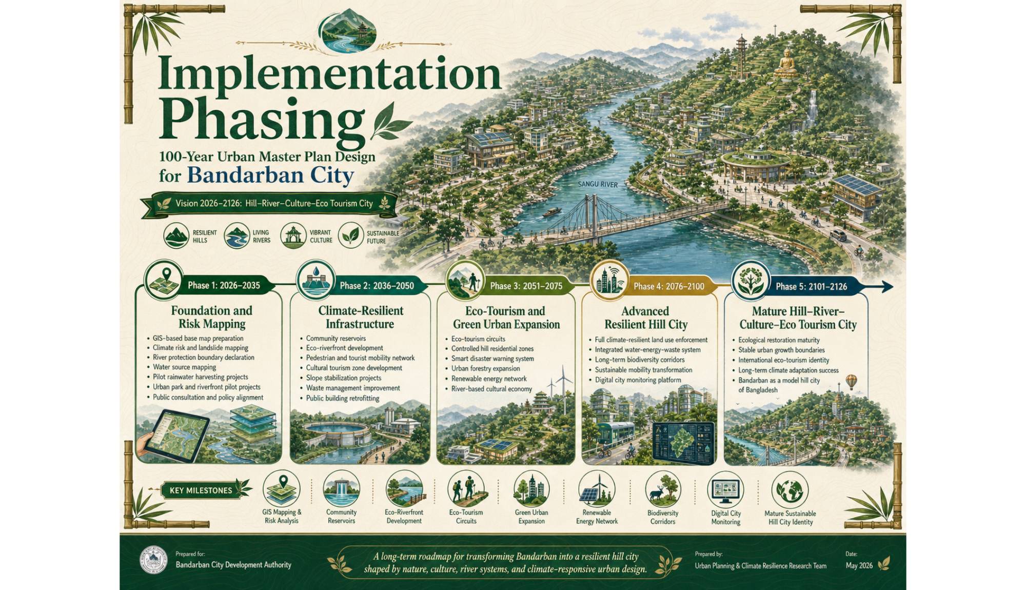
|
Time Period |
Planning Focus |
|
2026–2035 |
Climate risk mapping, river protection, basic infrastructure improvement |
|
2036–2050 |
Eco-tourism zones, water systems, mobility upgrades, urban greening |
|
2051–2075 |
Climate-resilient expansion, low-carbon infrastructure, cultural districts |
|
2076–2100 |
Advanced resilience systems, ecological restoration, smart hill city management |
|
2101–2126 |
Mature hill–river–culture city model with long-term ecological stability |
8. Climate Risk Analysis for Bandarban City
8.1 Landslide Risk
Bandarban’s steep slopes, intense rainfall, hill cutting, deforestation, and unstable construction increase landslide risk. Climate change may intensify rainfall events, making slope failure more frequent. Therefore, landslide risk zoning must become a primary layer in the master plan.
Recommended measures:
8.2 Flash Flood and Drainage Risk
The Sangu River and local streams can experience sudden water level changes during heavy rainfall. Unplanned construction near drainage paths can block natural water flow and increase flash flood risk.
Recommended measures:
8.3 Water Scarcity
Despite heavy rainfall, Bandarban faces dry-season water scarcity in many hill settlements. Climate change can make rainfall more irregular, increasing the importance of water storage and source mapping.
Recommended measures:
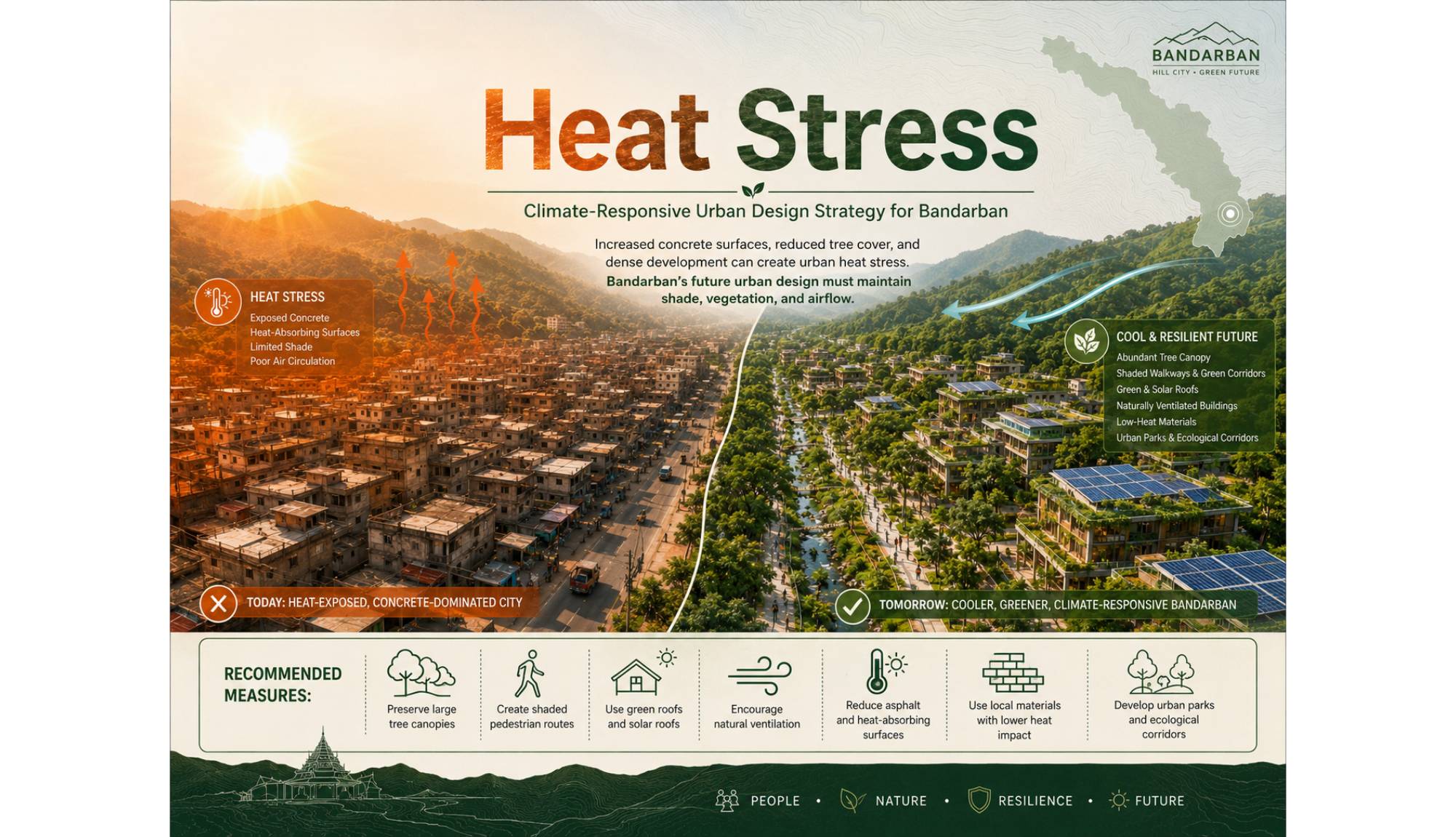
8.4 Heat Stress
Increased concrete surfaces, reduced tree cover, and dense development can create urban heat stress. Bandarban’s future urban design must maintain shade, vegetation, and airflow.
Recommended measures:
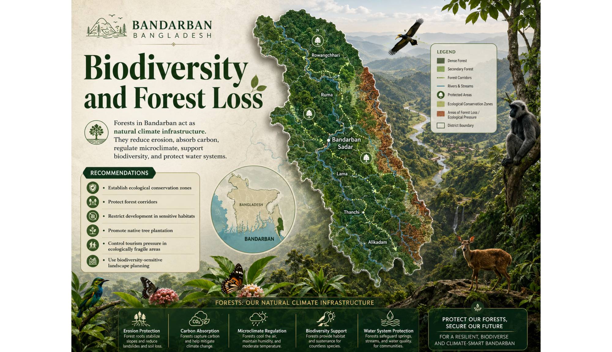
8.5 Biodiversity and Forest Loss
Forests in Bandarban act as natural climate infrastructure. They reduce erosion, absorb carbon, regulate microclimate, support biodiversity, and protect water systems.
Recommended measures:
9. Master Plan Vision: Hill–River–Culture–Eco Tourism City
The proposed master plan is based on four interlinked pillars.
9.1 Hill
The hill is the primary landform and identity of Bandarban. Urban development must respect slope, contour, vegetation, and drainage.
Planning principles:
9.2 River
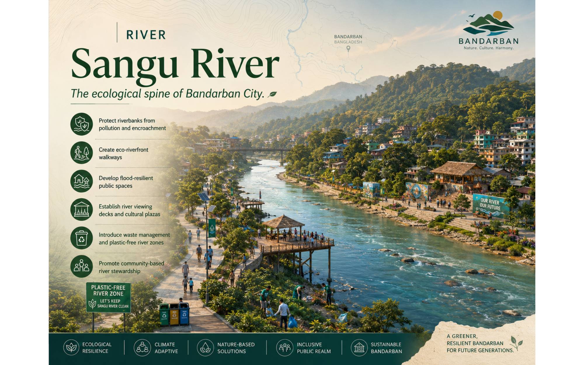
The Sangu River should be treated as the ecological spine of Bandarban City.
Planning principles:
9.3 Culture
Bandarban’s indigenous communities, crafts, festivals, food, language, music, textiles, and settlement traditions should become part of the city’s planning identity.
Planning principles:
9.4 Eco Tourism
Tourism should support conservation and local livelihoods rather than damage natural systems.
Planning principles:
10. Proposed Urban Structure
The future Bandarban City can be organized into a series of climate-responsive zones.
|
Proposed Zone |
Purpose |
|
Sangu River Ecological Corridor |
River protection, public walkway, biodiversity, flood buffer |
|
Hill Conservation Zone |
Forest protection, slope stability, restricted construction |
|
Cultural Heritage Zone |
Indigenous culture, craft, museum, festival space |
|
Eco-Tourism Zone |
Visitor facilities, interpretation center, eco-lodges |
|
Civic and Administrative Zone |
Government offices, public services, civic plaza |
|
Climate-Resilient Residential Zone |
Safe housing on suitable slopes and terraces |
|
Urban Green and Park Zone |
Children’s play, senior citizen walkways, gardens |
|
Water Security Zone |
Reservoirs, rainwater harvesting, springs protection |
|
Mobility and Transit Zone |
Pedestrian-friendly roads, shuttle routes, parking control |
|
Disaster Safety Zone |
Emergency shelters, evacuation routes, warning centers |
11. Land Use Planning Strategy
The land use plan should be based on environmental suitability rather than only market demand. Each site should be evaluated through slope, drainage, vegetation, accessibility, and hazard mapping.
11.1 No-Build Zones
No-build zones should include:
11.2 Controlled Development Zones
Controlled development zones may include moderate slopes where construction is possible with proper engineering, terracing, drainage, and vegetation protection.
11.3 Suitable Development Zones
Suitable zones should include relatively stable land where civic facilities, housing, tourism services, and public spaces can be developed with climate-sensitive design.
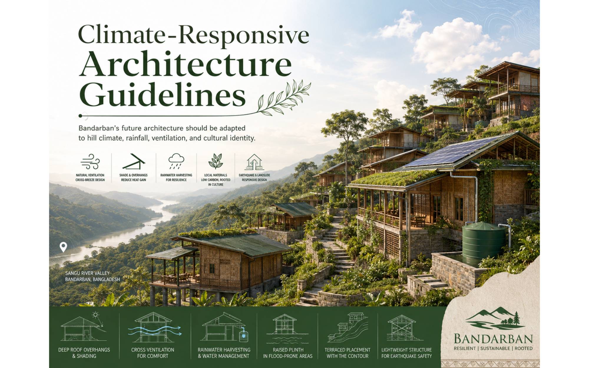
12. Climate-Responsive Architecture Guidelines
Bandarban’s future architecture should be adapted to hill climate, rainfall, ventilation, and cultural identity.
Recommended design guidelines:
13. Sangu Riverfront Development Strategy
The Sangu River should be planned as a protected ecological and civic landscape.
Proposed riverfront components:
The riverfront should not be over-concretized. It should remain soft, green, permeable, and flood-resilient.
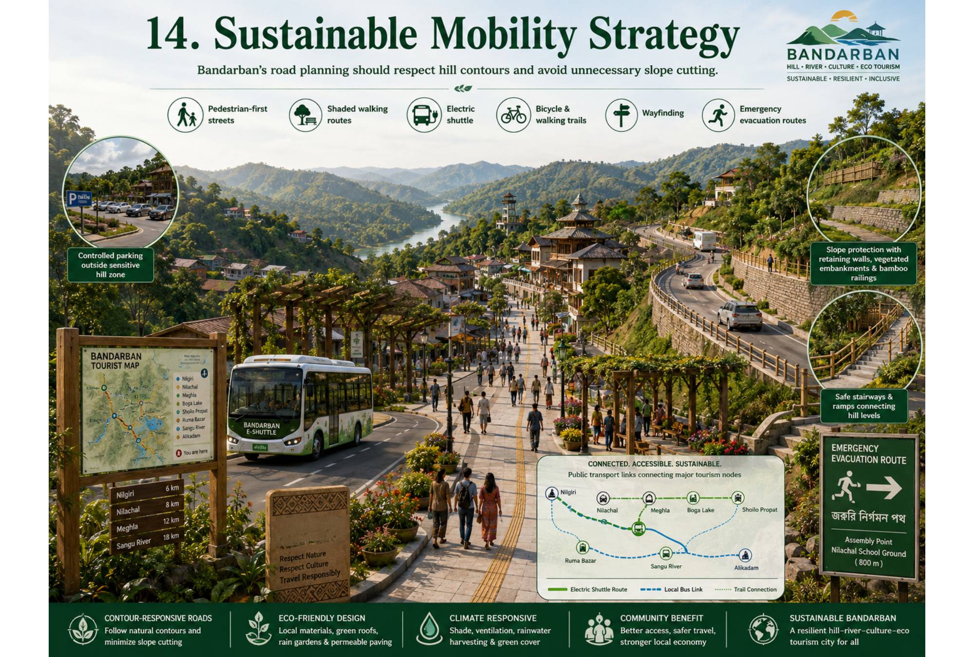
14. Sustainable Mobility Strategy
Bandarban’s road planning should respect hill contours and avoid unnecessary slope cutting.
Recommended mobility strategies:
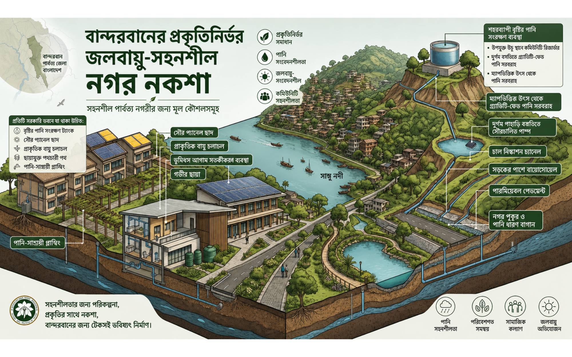
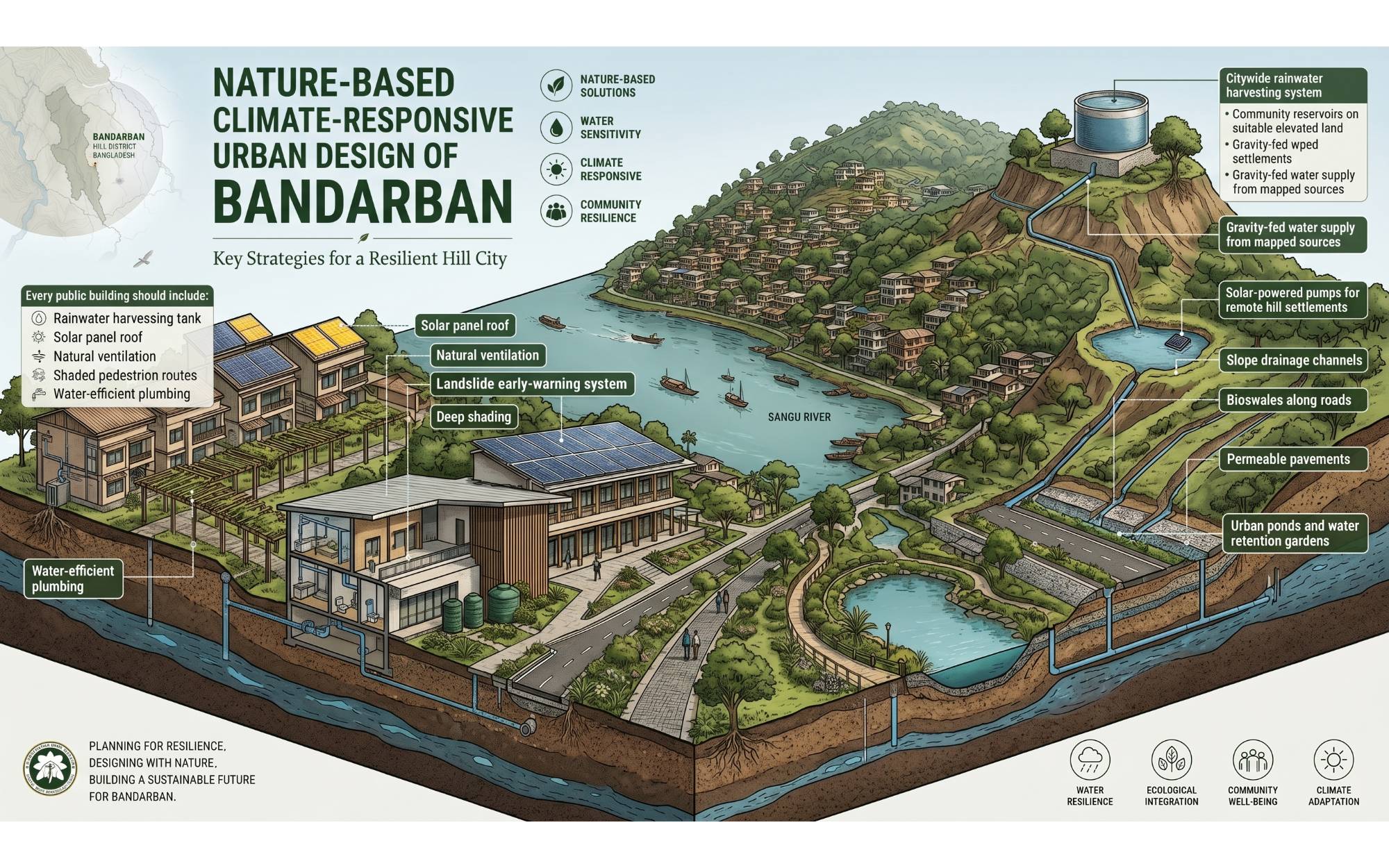
15. Water-Sensitive Urban Design
Water-sensitive planning is essential for Bandarban because of both heavy rainfall and dry-season scarcity.
Key strategies:
Every major public building should include:
16. Tourism Development Framework
Tourism should be planned through carrying capacity, environmental protection, and local economic benefit.
Proposed tourism strategies:
Tourism development must avoid uncontrolled resort construction, hilltop encroachment, river pollution, and displacement of local communities.
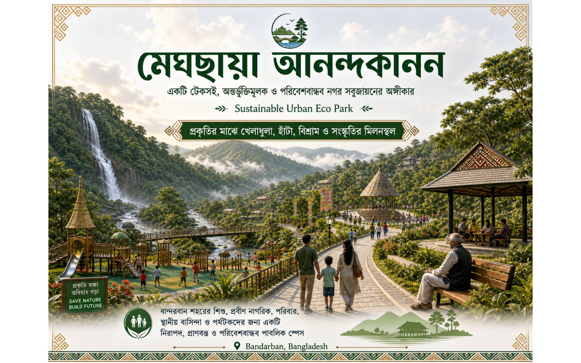
17. Public Space and Urban Park Strategy
Bandarban needs inclusive public spaces for children, senior citizens, tourists, and local residents.
Recommended public space components:
These spaces should reflect Bandarban’s landscape character through natural materials, shaded paths, and hill-sensitive design.
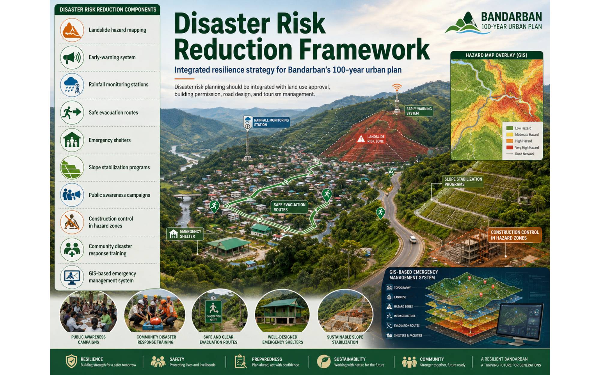
18. Disaster Risk Reduction Framework
Bandarban’s 100-year plan must include a strong disaster risk reduction system.
Key components:
Disaster risk planning should be integrated with land use approval, building permission, road design, and tourism management.
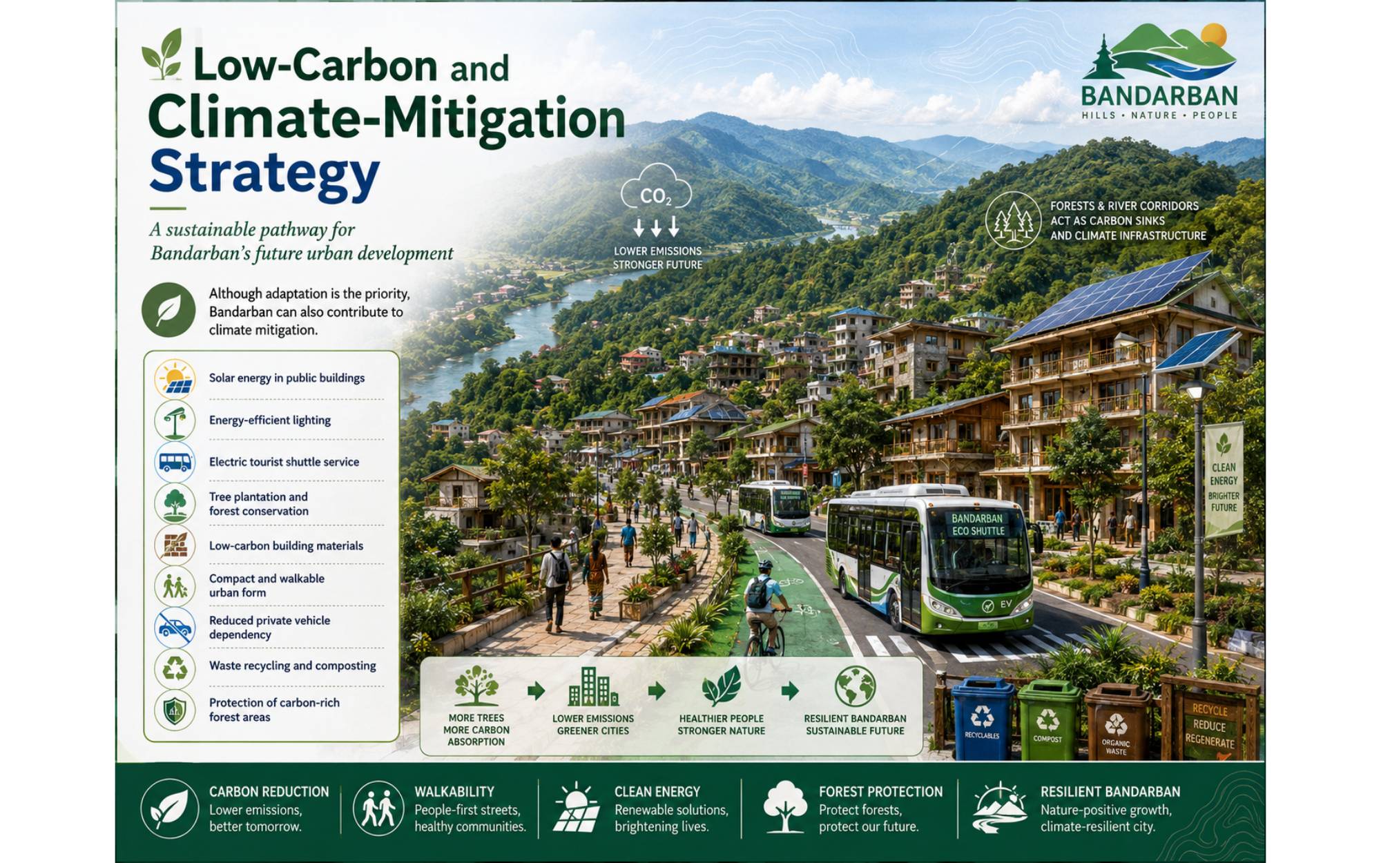
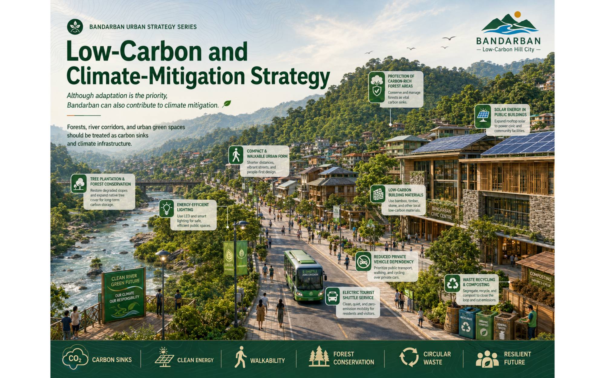
19. Low-Carbon and Climate-Mitigation Strategy
Although adaptation is the priority, Bandarban can also contribute to climate mitigation.
Recommended measures:
Forests, river corridors, and urban green spaces should be treated as carbon sinks and climate infrastructure.
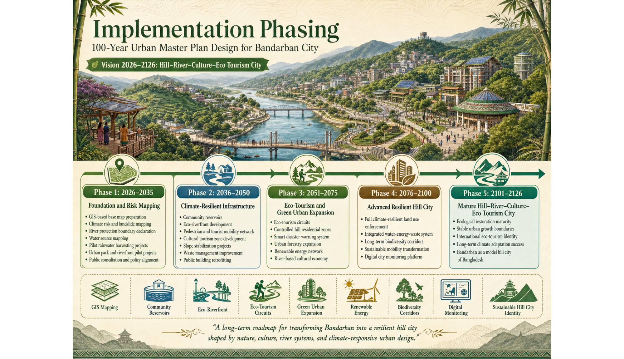
20. Implementation Phasing
Phase 1: 2026–2035
Foundation and Risk Mapping
Phase 2: 2036–2050
Climate-Resilient Infrastructure
Phase 3: 2051–2075
Eco-Tourism and Green Urban Expansion
Phase 4: 2076–2100
Advanced Resilient Hill City
Phase 5: 2101–2126
Mature Hill–River–Culture–Eco Tourism City
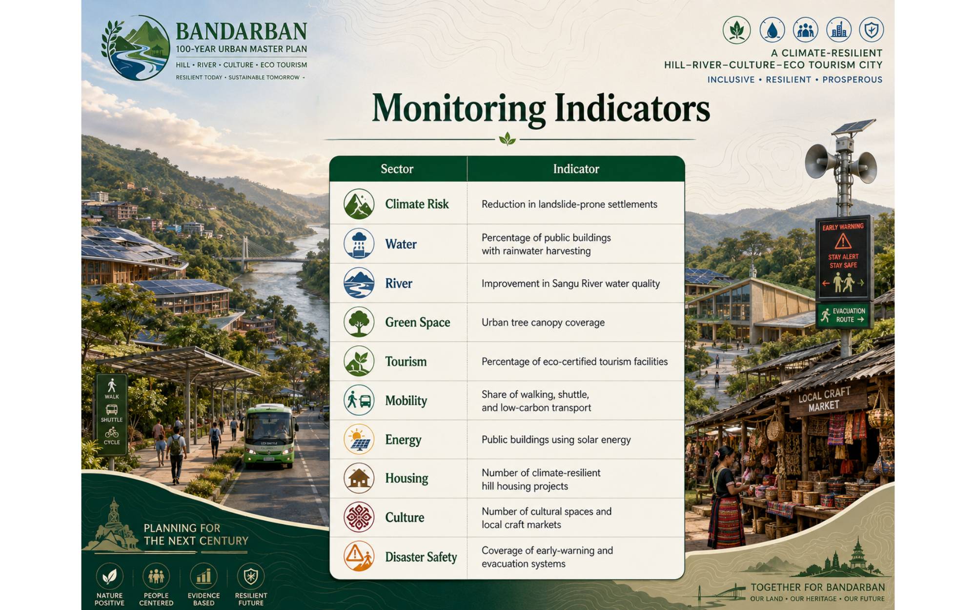
21. Monitoring Indicators
|
Sector |
Indicator |
|
Climate Risk |
Reduction in landslide-prone settlements |
|
Water |
Percentage of public buildings with rainwater harvesting |
|
River |
Improvement in Sangu River water quality |
|
Green Space |
Urban tree canopy coverage |
|
Tourism |
Percentage of eco-certified tourism facilities |
|
Mobility |
Share of walking, shuttle, and low-carbon transport |
|
Energy |
Public buildings using solar energy |
|
Housing |
Number of climate-resilient hill housing projects |
|
Culture |
Number of cultural spaces and local craft markets |
|
Disaster Safety |
Coverage of early-warning and evacuation systems |
22. Expected Outcomes
The proposed 100-year master plan is expected to produce the following outcomes:
23. Conclusion
The future of Bandarban City depends on how carefully it balances urban growth with hill ecology, river protection, cultural identity, and climate resilience. A 100-year master plan for Bandarban cannot be only a physical development plan; it must be an ecological and cultural commitment. The city should not imitate flatland urban models. Instead, it should become a model hill city where development follows the land, water is managed through nature-based systems, tourism supports local communities, and the Sangu River remains the heart of public life.
The vision “Hill–River–Culture–Eco Tourism City” offers a long-term framework for transforming Bandarban into a resilient, inclusive, and environmentally responsible urban settlement. Considering the climate change challenges of Bangladesh, this master plan can position Bandarban as a national example of climate-responsive hill urbanism for the next century.
References
Bangladesh Planning Commission. (2018). Bangladesh Delta Plan 2100. Government of the People’s Republic of Bangladesh.
Government of Bangladesh. (2009). Bangladesh Climate Change Strategy and Action Plan. Ministry of Environment and Forests.
Government of Bangladesh. (2021). Nationally Determined Contributions 2021. Ministry of Environment, Forest and Climate Change.
Government of Bangladesh. (2022). National Adaptation Plan of Bangladesh 2023–2050. Ministry of Environment, Forest and Climate Change.
IPCC. (2021). Climate Change 2021: The Physical Science Basis. Cambridge University Press.
IPCC. (2022). Climate Change 2022: Impacts, Adaptation and Vulnerability. Cambridge University Press.
IPCC. (2023). Climate Change 2023: Synthesis Report. Intergovernmental Panel on Climate Change.
UN-Habitat. (2020). World Cities Report 2020: The Value of Sustainable Urbanization. United Nations Human Settlements Programme.
UNDRR. (2015). Sendai Framework for Disaster Risk Reduction 2015–2030. United Nations Office for Disaster Risk Reduction.
UNWTO. (2018). Tourism and the Sustainable Development Goals: Journey to 2030. World Tourism Organization.
Have a question? Chat with us on WhatsApp and we'll get back to you shortly.